Remote Sensing
What is it?
It is simply the process of collecting information about the earth’s surface without having to be physically present. Remote sensing is becoming a much more valuable tool in the management of forest land and other natural resources. Today remote sensing utilizes different types of satellite imagery or digital aerial photos as the medium from which critical information is extracted.
As more and more imagery providers enter the market, the cost of imagery acquisition is declining rapidly. At the same time the quality and variety of imagery available has become almost overwhelming. Add to this the ability to collect data without having to invest in time and transportation to visit the field (field visits for ground truthing are sometimes necessary and advisable) and the benefits become very attractive. FORSight utilizes remote sensing to provide timely, accurate and cost effective digital data that can be analyzed any number of ways and then integrated into existing forestry GIS systems.
What uses does remotely sensed data have?
From verification of merchantable inventories for potential acquisitions to assessing damage from natural disasters, remote sensing technology is emerging as the tool of choice. Other uses that have become commonplace are:
-
Area measurement
- Forest vegetation type classification
- Stand boundary delineation
- Forest fragmentation assessment
- Wetlands identification
- Soil erosion assessment
- Stand damage assessment
- Land-use change (urban sprawl) detection
- Change detection
Technology for today
Remote sensing has taken huge strides forward in both applicability and reliability. Imagery that used to take weeks or months to secure can now be obtained in days. Remote sensing is a mature technology taking advantage of many recent innovations and refinements
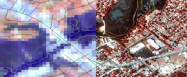
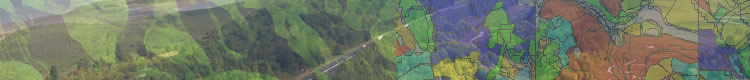
30 m resolution (satellite) versus 1 m resolution (airborne scanner)
Where does FORSight Resources fit in?
FORSight Resources has the expertise and experience to assist clients through all phases of a remote sensing project. We are not affiliated with a particular imagery provider and we do not sell imagery. This allows us to make an unbiased determination of which imagery product will meet our client’s needs. Our focus is on the extraction of critical information quickly and accurately.
FORSight Resources is also not tied to any one remote sensing technology. We use both traditional pixel classifiers (ERDAS Imagine™) as well as the newer object-based classifiers (eCognition™). When necessary, our forestry experts can perform on-screen digitizing and manual classification of images.
What does a typical project entail?
Our process is direct and efficient, consisting of the following steps:
- User-needs assessment to determine client objectives
- Acquire appropriate imagery (cost vs. benefit)
- Prepare imagery for processing (create mosaics; correct for distortions; orthorectify)
- Process imagery based on client needs
- Enhance and classify images
- Data extraction and summarization
- Perform analyses on 'remotely sensed' data
- Change detection processing
- Format outputs to meet client needs (digital, hardcopy, tabular)
- Integrate information into existing GIS
Contact us today to see how we can help you leverage your GIS investment and maintain the value of your data.
|